
I’d like to introduce NomadTrails – a new type of story I will be writing about here on on NomadPhotographer. These trail reports of hike, walks, and runs I have done on my travels will include the details that matter most, my favorite images, and stories from my adventures. Enjoy!
NomadTrails
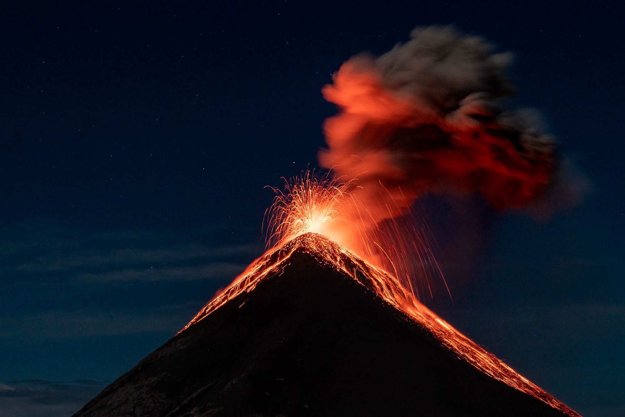
As anyone who has been to Antigua, Guatemala will know, the first thing most travelers and locals will ask is “have you done the volcano hike yet?” The city is absolutely dominated by Volcán de Agua and in the distance Volcán de Fuego and Volcán Acatenango. While all three volcanos are imposing, only one, Fuego, is currently active. Erupting every 10-30 minutes, Fuego sends small gas and ash eruptions flying high above its cone. The gas and clouds are visible from Antigua during the day and on clear nights, you can see glowing lava rolling down its slopes.
The hike that is on everyone’s mind is the trail up Volcán Acatenango, the sister volcano to active Fuego. The trail starts an hour outside of Antigua and meanders up the north face of the mountain, skirts around to the east, before reaching base camp facing the saddle between Acatenango and Fuego. Once at camp, hikers are given an option of traversing the saddle and getting an up close and personal view of the fiery eruptions. Early the next morning, the groups then head for the summit of Acatenango to watch the sunrise over the Antigua valley with views of all three volcanoes.
After shopping around town and online, I decided to go with CA Travelers for my outfitter on the recommendation from several friends. They are one of the top two companies that were popular among the people I met. The other company, Wicho and Charlie’s, also would be a top choice if you find CA Travelers is fully booked. Both are in the middle of the price range of $30 to upwards of $150!
NomadTip
On my travels, I generally find that the midrange companies suit me best. I rarely recommend the basement price points. There is usually a reason that they are so much cheaper than others!
The day of the excursion, myself and my friend Tonia were picked up from our hostel and driven to CA Travelers’s headquarters about 20 minutes away. There we were able to rent a hiking pack (which I did), get our included warm gear, pick our food options (meat, veggie, vegan or gluten-free), and meet the others on our trip. We would be a group of 23, which is bigger than most other groups, but it turned out to be a non-issue.
Once everyone was packed, we piled in the shuttle for an hour long drive to the trailhead at La Soledad and an altitude of 7872ft/2340m. During the drive, CA owner Farah gave lots of history and information about the region and the volcano. Upon arrival we were able to rent walking sticks for USD$3 (highly recommended) and hire a local porter if needed.
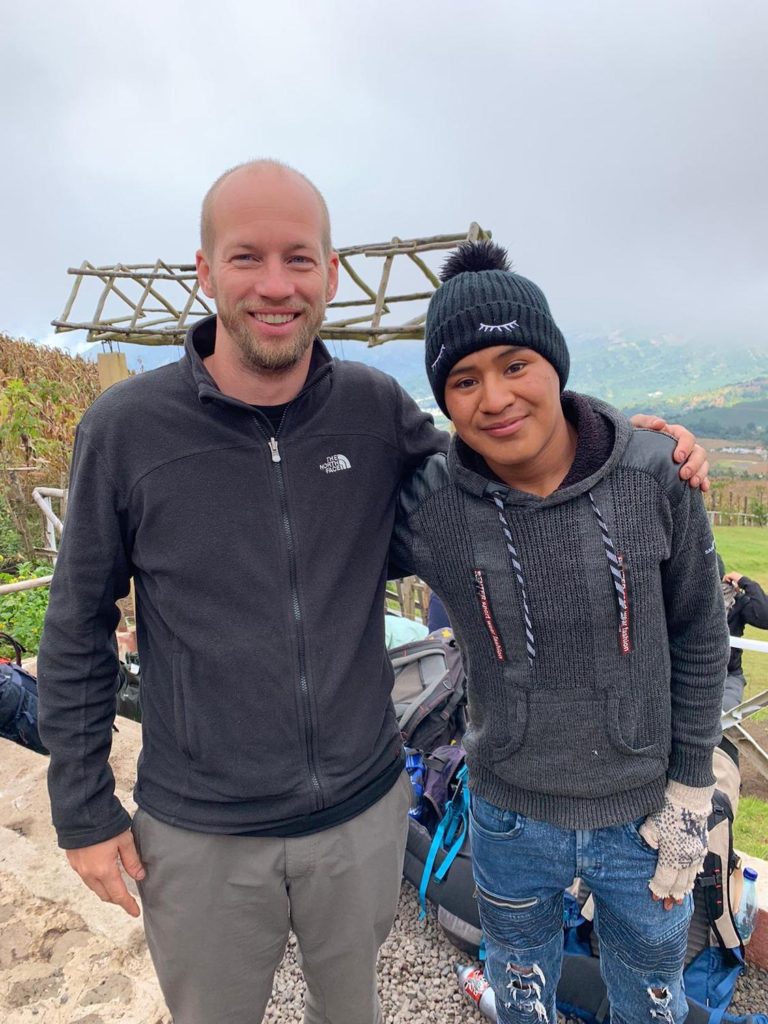
I decided to hire a porter for $10 each way as last May I had sprained my knee badly. I couldn’t run or walk without pain for 6 weeks and while it was now healed, I worried that a strenuous hike might injure it again. The porters are from the local community and the money they earn goes directly to them. My porter, Denis, was great and we spent a majority of the hike talking about his life and aspirations. He is just 16, is taking night classes to learn English, and hopes to one day be a guide on the mountain.
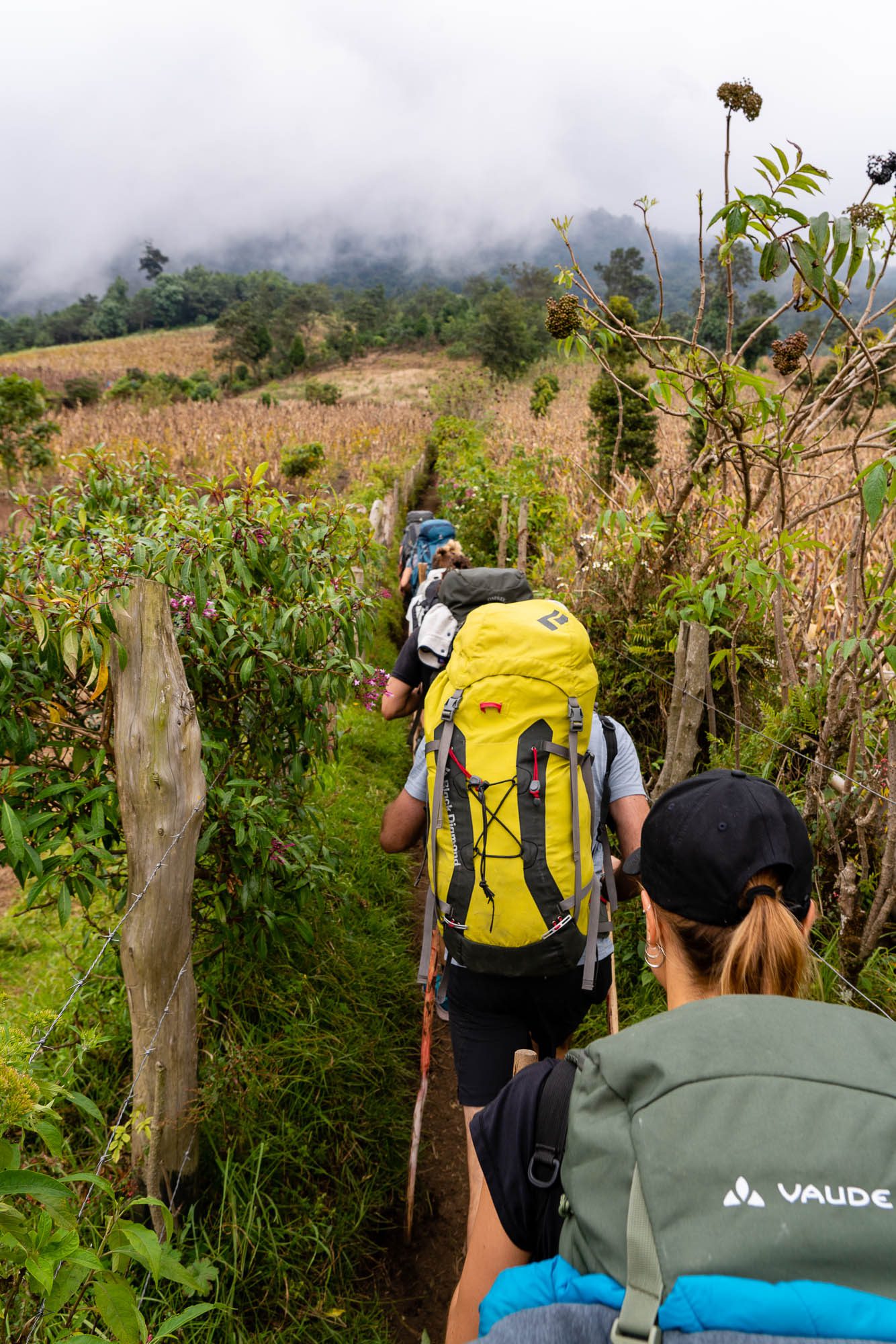
We took a team “before” photo, grabbed our packs and set out. I had my 3 liter camelback, camera, rain poncho, and other small accessories loaded in my day pack. I was happy to be able to easily access my camera while on the trail. It was much easier than having to dig it out of my big bag! I had heard from other travelers that the first pitch on the trail was the hardest and they were so right.
The trail starts steep right away, your legs are complaining, and your lungs start to struggle in the thin air. Almost immediately I began to sweat and wonder what I had gotten myself into. The trail surface was variably soft and crumbly then hard packed dirt making it difficult to find a good pattern. Uneasily I settled into a rhythm of looking up and ahead at the passing corn and bean fields rather than down at my aching legs. After about 40 minutes, we made it to a funny little rest stop featuring toilets, some seating, and a couple small food vendors.

After the first initial slog and rest at the funky coffee shop and courtyard, our guide signaled that it was time to continue. As we resumed our pace, the trail narrowed to a single file line and our team pushed ahead at a respectable clip. We ended up passing a Wicho and Charlie‘s group that appeared to be struggling with fitness level – I’m glad I was with an active group!
After just 15 minutes we left the corn fields behind and entered the cloud forests passing through 9000ft/2740m altitude. The dense, forested jungle started suddenly and was all enveloping. Ferns and moss clung to trees, we dodged serpentine vines hanging down from the canopy, and threw on our rain jackets as the mist clung to everything.
Soon after entering the forest, we arrived at the municipality fee station where we paid our 50GTQ (USD$6.50) to enter the protected area. It was at this point that anyone not wearing pants put them on, as the temperature had dropped quickly. Head guide Jonás informed us that we would push onward to 9800ft/3000m where we would have our lunch stop.
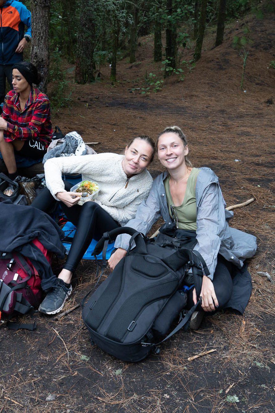
Our break for food was a welcome respite from the intense 2.75 hours preceding. We made temporary camp in a clearing of trees near the transition to alpine forest. Everyone eagerly tore into our more than ample lunches. My non-vegetarian version included one pound! of barbecue chicken, rice, salad with ranch dressing, and a banana. As this was our first time seeing the food, many of us were surprised by its abundance. No one would be starving these next two days!
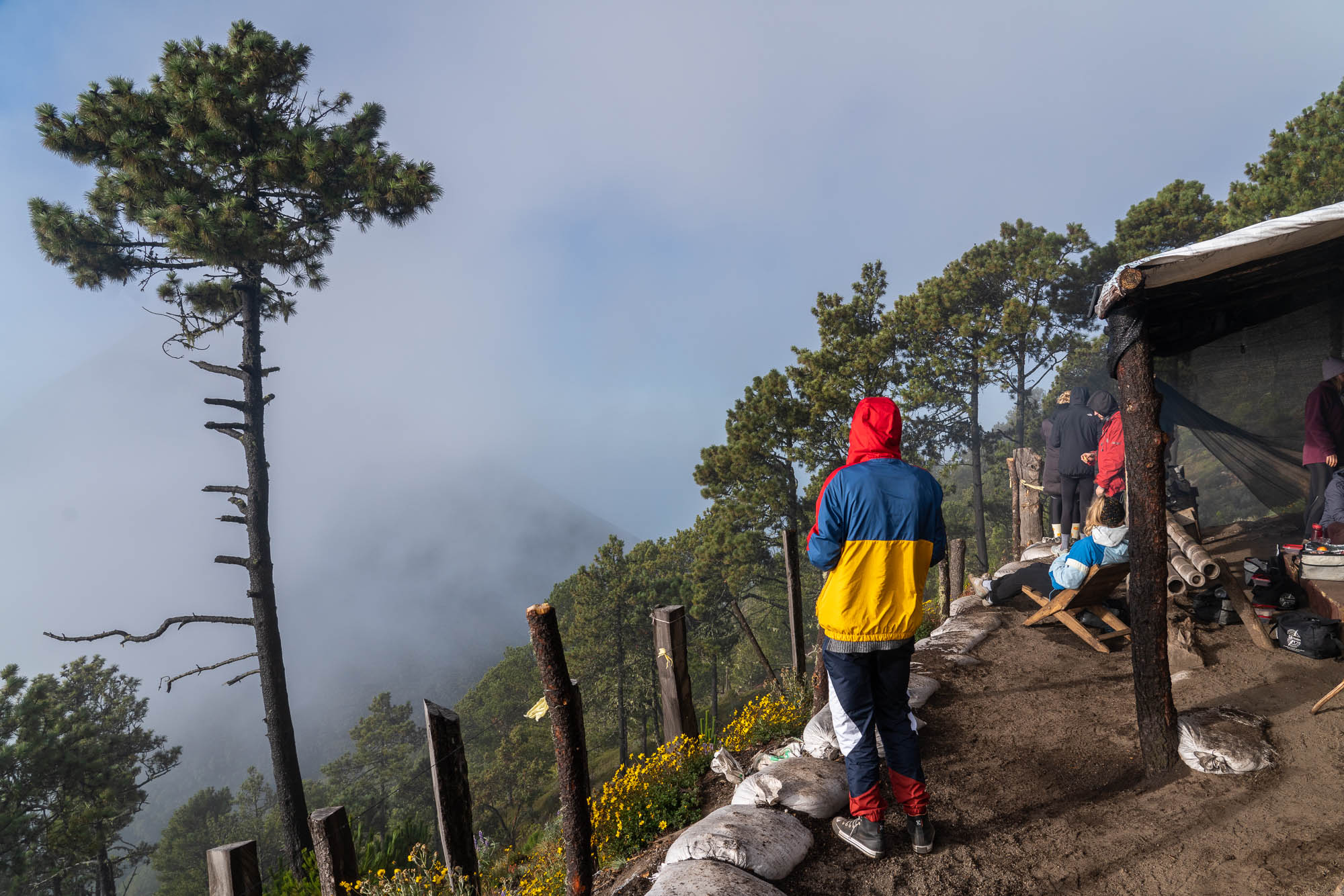
About an hour after lunch, we fully broke out of the cloud forest and entered the high alpine climate leaving behind the ferns and moss and replacing them with tall pine trees, thistles, blueberry bushes, and wildflowers. The trail became easier at this point as we began to traverse the eastern slope of Acatenango. This section ran on for about 45 minutes before one last final 30 minute incline up to the campsite. As you cross into the campground, tourists pay a 60 GTQ ($7.80) fee to stay overnight.
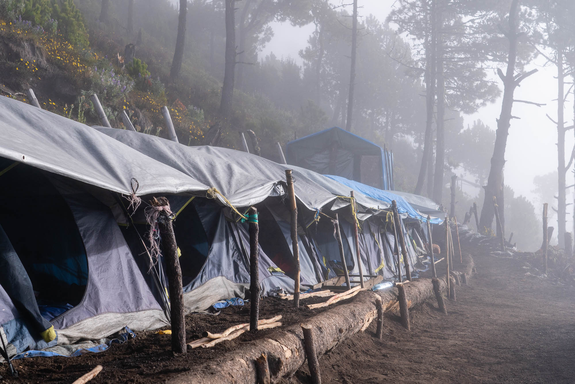
The CA Travelers basecamp is positioned the farthest south on the slope of Acatenango, which meant we were well oriented to see Fuego erupt. That is if we could see anything! The clouds were thick and all-encompassing when we arrived and all we could sense of the power beyond were occasional rumbles. With nothing, but the odd glimpse of mountain, we set to making camp. CA has a permanent presence on the mountain which means no set up for customers! We were assigned tents based on the size of the groups we booked with. Since I booked on my own, I got my own tent, score! Each tent is waterproof, spacious, and included a 6-inch thick sleeping pad. I was comfortable all night long!
As the late afternoon changed to evening, we got a few breaks in the clouds and saw our first up close eruptions – but the real show would follow once the sun went down. As night approached, we were treated to a lightning storm off to the west of Fuego and eery purple haze as the clouds rolled past. The guides set to cooking our dinner and we waited for the real light show to begin.
Dinner consisted of yet more large meals to replenish our energy after our big day. The regular menu included beef bolognese pasta, baguette with butter toasted on the campfire, and red wine!
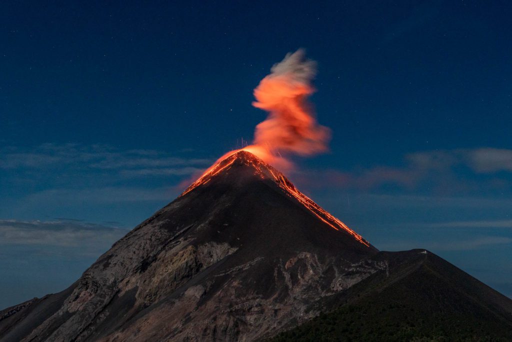
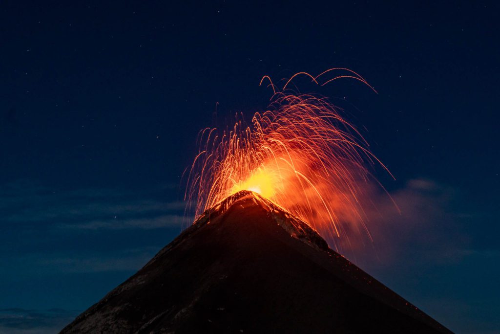
After dinner, the clouds began to mercifully clear. What had only been fleeting glimpses of Fuego turned into near uninterrupted views of the peak and its eruptions. I had brought a small gorillapod tripod with me to help with night shots and I set it up on a nearby fencepost. Every few minutes, the mountain would rumble to life and we would collectively let out shouts of “ooo” and “aaa”.
It was around this point that Jonás decided that for those who wished, the team would set off to do the Fuego saddle hike. This additional fee trek (200 GTQ/USD$26) takes hikers to the absolute limit of the safe viewing distance for an up close and personal experience with the active volcano. After he told us it would take an additional 3 hours roundtrip for this portion and that it was a very challenging hike, I opted out. My knee was feeling good, but I felt it wise not to push it. And besides, the views from camp were epic.
While the brave – or foolhardy – set off for the saddle, the rest of us sat around the campfire drinking wine, chatting about our lives, and taking in the views. Around 10pm, with my memory cards filling up and feeling the effect of altitude after a couple glasses of wine, I turned in, with fingers crossed for more great views the next day.
The plan for the morning was to awake at 3:30am to prepare to leave at 3:45am for the summit of Acatenango. Sadly, upon sticking my head out of my tent at 3:30, I could tell there would be no summit attempt for our group. The clouds that had plagued us the evening before were back in full force. I could hardly see tents just a few meters away. I struggled out of the tent to find Jonás and he confirmed that there was no reason to try.
I went back to sleep for a few more hours and woke to the team cooking breakfast. Once again, the food was extensive with two slices of toast, toppings of Nutella, peanut butter, and jam, an egg muffin, and cereal with fresh strawberries!
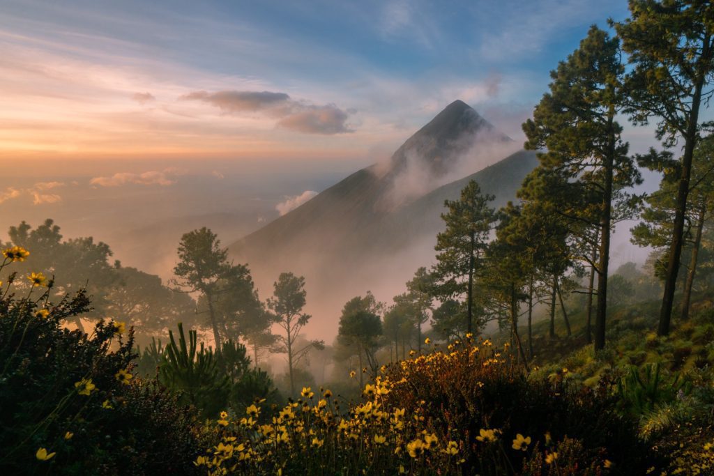
I wandered the camp with my camera capturing some magical scenes as the sun lifted above the cloud layer revealing Agua and Fuego in rose colored hues. My absolute favorite frame from the trip is below. It perfectly captures the interplay between the myriad of colors and textures at base camp.
After we’d eaten, it was time to head down. I threw on my soft knee brace that I usually work out in as I was concerned about the upcoming 1500m of vertical descent. And man am I glad I did. After just 30 minutes of leaning into my walking stick, my good knee was already complaining! The descent flew by as we dropped altitude quickly passing from volcanic, to high alpine, to cloud forest, and finally farmland. We paused once more at the quirky rest stop and nearly everyone took the chance to grab a coffee or hot chocolate to refresh.
Another 10 minutes of descending past the mini-camp, we made it to the trailhead. We returned our walking sticks, said farewell to the guides and porters, and took team photos before boarding our shuttle back to CA Travelers home base.

The trip cost 350 GTQ (USD$45) when I went in November 2021. This price included additional warmth and outdoor gear (jacket, thick gloves, balaclava, headlamp, camelback with 3 liters of water, sleeping bag liner), lunchbox with a large amount of food (I didn’t go hungry), first aid kit, and rain poncho. Additional gear like a bigger pack could be rented for a small fee. There are also two locations on the mountain where you pay the local municipality to visit. These total 110 GTQ ($14) as of November 2021.
I’m really glad I did the hike, but I doubt my knee would have been able to support me had it not been for my porter Denis. Know that the way up can get strenuous and the way down isn’t much easier on your joints – but the views are next level! Have you ever hiked a volcano and if not would you?
February 4, 2022
Logan, your photos are awesome! Makes me want to go back.
February 4, 2022
Love the blog! Great descriptions – It was like I was there with you. Knee pain and all!
February 4, 2022
Wow – amazing photos, Logan. I’ve been there many times, but never saw anything like this.
March 8, 2022
I was there with Logan and I can promise you that the description is as accurate as it can get. Thank you for beautifully capturing the experience not only in pictures and descriptions, but also stories. Takes me right back.
To everybody hesitating if you want to do it and reading this as pre-research. DO IT!